Enregistrez gratuitement cette image
en 800 pixels pour usage maquette
(click droit, Enregistrer l'image sous...)
|
|
Réf : V01954
Thème :
Terre vue de l'espace - Mers - Côtes - Caps - Péninsules (601 images)
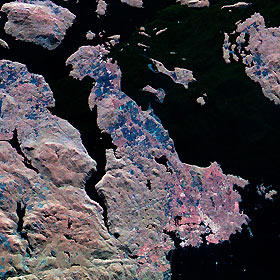
Titre : Space Radar Image of Victoria, Canada
Description : (La description de cette image n'existe qu'en anglais)
This three-frequency spaceborne radar image shows the southern end of Vancouver Island on the west coast of Canada. The white area in the lower right is the city of Victoria, the capital of the province of British Columbia. The three radar frequencies help to distinguish different land use patterns. The bright pink areas are suburban regions, the brownish areas are forested regions, and blue areas are agricultural fields or forest clear- cuts. Founded in 1843 as a fur trading post, Victoria has grown to become one of western Canada's largest commercial centers. In the upper right is San Juan Island, in the state of Washington. The Canada/U.S. border runs through Haro Strait, on the right side of the image, between San Juan Island and Vancouver Island.The image was acquired by the Spaceborne Imaging Radar-C/X-band Synthetic Aperture Radar (SIR-C/X-SAR) on October 6, 1994, onboard the space shuttle Endeavour. The area shown is 37 kilometers by 42 kilometers (23 miles by 26 miles) and is centered at 48.5 degrees north latitude, 123.3 degrees west longitude. North is toward the upper left. The colors are assigned to different radar frequencies and polarizations as follows: red is L-band horizontally transmitted and received; green is C-band, vertically transmitted and received; and blue is X-band, vertically transmitted and received. SIR-C/X-SAR, a joint mission of the German, Italian and United States space agencies, is part of NASA's Mission to Planet Earth program.
|
|

